


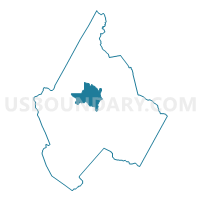
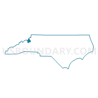
Voting District 14, Avery County, North Carolina
About
Outline

Summary
| Unique Area Identifier | 639315 |
| Name | Voting District 14 |
| County | Avery County |
| State | North Carolina |
| Area (square miles) | 8.49 |
| Land Area (square miles) | 8.49 |
| Water Area (square miles) | 0.00 |
| % of Land Area | 100.00 |
| % of Water Area | 0.00 |
| Latitude of the Internal Point | 36.10882080 |
| Longtitude of the Internal Point | -81.93754030 |
Maps

Graphs
Select a template below for downloading or customizing gragh for Voting District 14, Avery County, North Carolina


Neighbors
Neighoring Voting District (by Name) Neighboring Voting District on the Map
- Voting District 02, Avery County, NC
- Voting District 05, Avery County, NC
- Voting District 12, Avery County, NC
- Voting District 13, Avery County, NC
- Voting District 15, Avery County, NC
Top 10 Neighboring County Subdivision (by Population) Neighboring County Subdivision on the Map
- Banner Elk township, Avery County, NC (2,996)
- Newland No. 1 township, Avery County, NC (1,189)
- Newland No. 2 township, Avery County, NC (1,096)
- Montezuma township, Avery County, NC (676)
- Cranberry township, Avery County, NC (614)
- Minneapolis township, Avery County, NC (384)